|
Home |
|
 |
|||||||||||||
|
|
|||||||||||||
|
Measure Simply & Fast! Most features COMPLETELY FREE! Farmers can measure fields, boundary distances & calculate areas. Estate agents can measure land parcels easily. Route planners can measure road dictances. If you have an image then we can measure from it - quick & simple. No mapping software, or higher knowledge required! Scan it. Scale it. Measure it! Free download! Free Upgrades! Free Support! Only £39.99 for full version! |
|||||||||||||
|
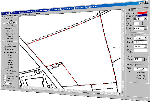
Field Track - Map Measure is a small, simple, and cost effective solution to measuring distances, areas and angles from scanned images (maps). This is a completely free to download and use map/image measurement system. Field Track - Map Measure was designed to cover a very obvious need for farmers - a simple and cheap program to measure stuff with! High ownership and support costs, as well as, difficulty learn and use are the main drawbacks of many similar tools currently available. In fact many similar packages are over priced for the simple task of measuring an area of your field. Field Track - Map Measure is to allow extremely simple and fast use of your field images and maps. Field Track - Map Measure is also currently totally FREE to download and use in a restricted fashion. If you register Field Track - Map Measure for the insanely low price of £39.99, you will gain access to several extra features and also stop any 'nag' screens from appearing. Field Track is continually providing simple and effective computer solutions for farmers and related industries. |
|||||||||||||
 |
|||||||||||||
|
Click image to enlarge |
|||||||||||||
|
Mapping software is expensive and usually quite complex for the simple requirements of quickyl mapping off a parcel of land, or measuring the distance along a boundary. Field Track - Map Measure is not a replacement for a true mapping package, it must be noted. If your needs are more orientated around true mapping, for example, shape files, yield monitoring, soil analysis plot maps and other GPS related work then Field Track - Map Measure is NOT for you. May we possibly suggest one of the below options: If, on the other hand, you have a scanned image file of a map on your computer and want to quickly scale and mark out measurements upon it - simply and quickly, then Field Track - Map Measure is an ideal and cost effective solution for you. What possible uses might you have for Field Track - Map Measure?
Field Track - Map Measure is currently free to download and use in a slightly restricted manner (some features do not work). Be sure to download your copy today before we change our minds! To download Field Track - Map Measure please complete the below information and then press the ‘Download’ button: Your e-mail details maybe used by ourselves to communicate important information with yourself, however your details are not otherwise used, or sold in any way. This is our privacy policy to all our customers and visitors. |
|||||||||||||
|
|
|||||||||||||
 |
|||||||||||||
|
© Copyright RedkiteIt Limited All rights reserved. |
|||||||||||||